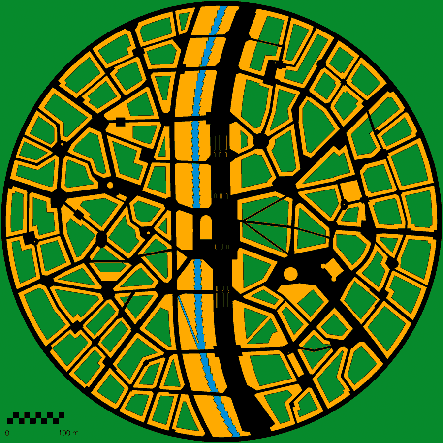
  The Reference District is 760m (2500') in diameter. (click to open zoom) 1999 J.Crawford
If the design for the city as a whole is to work, each district must meet a number of design criteria. Design standards for the Reference District are given below and serve as a yardstick against which to measure district designs. The standards must be reached by the average district; districts far from the center can be less dense but districts at the very center should be denser. (This is reflected in the Reference Topology.)
Unique DistrictsEach district should have its own distinct character and style of architecture, with a unique pattern of streets, squares, and buildings. Streets should curve gently, and a number of small squares should be located in each district. Each building should differ from its neighbors, in the way that cities were always built until the 20th century.
Radial DesignA radial design minimizes walking times to the center of the district, where the transport halt is located, and brings open space close to all parts of the district. The transport halt is a natural central focus for each district and the logical location for shopping. The number of district designs is limitless. View some other possibilities.12,000 ResidentsThe average population of a district is 12,000 residents. Each circular district divides along the central boulevard into two communities of roughly equal size. These communities each have a population of about 6000 residents and are small enough that people feel they belong to a community in which their voice can be heard.2500 Foot (750 Meter) DiameterThis derives directly from the requirement that the central transport halt lie within a five-minute walk. (A brisk walking speed is about 250 ft./min. or 75 m./min.)1.5 Floor Area RatioThe required Floor Area Ratio is about 1.5. This relatively high ratio means that, within each district, 38% of the land must be built upon to an average height of four floors. The remaining 62% is dedicated to streets and open space, generally in the form of interior courtyards. These figures are based on the following per-capita gross floor area allocations:
Narrow StreetsStreets average 25 feet (7.5 M) wide. A boulevard 100 feet (30 m) wide connects all the districts in a lobe and provides a high-speed bicycle thoroughfare. The metro system is constructed beneath this central artery. Other streets should be at least 16 feet (5 meters) wide to allow for access by emergency vehicles. Small alleys not long enough to require direct emergency access can be much narrower - as little as 6 feet (2 meters). Varying widths add interest to an area.Mixed UsesJane Jacobs contends that the long-held urban-planning principle of separation of uses is not only unnecessary but actually antithetical to the creation of vibrant urban areas. The move to separate industry from residential areas dates from a period in the late 19th and early 20th centuries when smokestack industry was the norm, and it remains appropriate to separate heavy industry from residential and commercial areas. Heavy industry is situated in the uninhabited utility areas. With judicious safeguards, commerce and light industry can readily be mixed with residences, as was usual until recent times. Mixed uses add interest and life to a neighborhood. |
Continue on to Blocks
Return Home
E-mail
carfree.com
1996-2016 J.Crawford