
|
||
|
Issue 63 |
|
12 September 2011 |
|
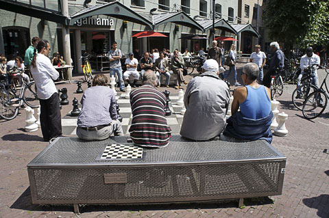
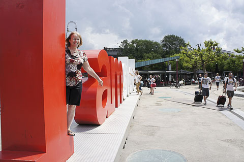 I amsterdam Cheesy as it is, people love this thing. Museumplein, Amsterdam ©2011 J.Crawford AnnouncementsSome Changes in Carfree TimesThere will be somewhat more emphasis on external links and correspondingly fewer articles. The Hot Links section will remain at the end of each issue and will now be accompanied by brief descriptions of each link. The typical Carfree Times reader will find most of these links rewarding.Carfree ConversionsCarbusters recently published the final installment in my series on carfree conversions. I also took this opportunity to improve the Conversions section at Carfree.com, where all six articles in the Carbusters series are now on line.VideoI recently returned from a long trip through Amsterdam and northern Spain. I now have about 13 hours of video and hundreds of new photographs. In the months ahead I intend to put a number of videos on line. Notices will appear here and on the Carfree_Cities list. The quality of the raw footage is remarkable, compared to the 16mm film I cut my teeth on more than 40 years ago. This footage is also in color and has synchronized sound. This was all possible a long time ago, if you had enough time and money. Today it's cheap and easy.The first video, Parking in Pontevedra, is amusing (opens in a new window). The BooksCarfree Cities and Carfree Design Manual are widely available in Europe and North America.
 Museumplein, Amsterdam ©2011 J.Crawford
World Carfree NetworkCarfree.com actively supports World Carfree Network (WCN). The main news from the network follows. WCN could use your help if you have time available.World Carfree NewsWorld Carfree News is now available in Czech, English, French, German, Italian, Portuguese and Spanish. It's a great way to keep abreast of important developments in the carfree cities network.CarbustersCarbusters has moved on line. The content is unchanged, but it is now easily accessible by internet, and it's free.
|
 Museumplein, Amsterdam ©2011 J.Crawford News BitsMethane Hydrates Are Really DangerousThe massive extinctions that occurred 200 million years ago did not come directly from intense volcanic activity, as had once been thought, but through a chain reaction that was merely initiated by volcanism. And that's bad news for our own climate future.The extinctions that occurred at the end of the Triassic period were driven by high levels of greenhouse gases, but most of the gases were not released by volcanoes. New research at the University of Utrecht, recently published in Science, shows that the volcanoes released significant amounts of CO2 which in turn caused moderate warming of the climate. This, however, led to the large-scale release of methane from the sea bottom. (Methane is a much more powerful greenhouse gas than CO2.) This then caused the extreme climate change and acidification of the oceans. Biodiversity on land and sea was dramatically reduced. The research also indicated that the amount of carbon now being released by burning fossil fuels was in the distant past sufficient to cause extreme climate change and mass extinction. Once the temperature of the oceans reaches a critical threshold, the stability of methane-hydrates on the sea floor is upset, with rapid and enormous climate change the likely result.
"Massa-uitsterving kwam niet door C02; baart zorgen voor toekomst"
 Museumplein, Amsterdam ©2011 J.Crawford Another Bio-Fuel Bites the DustThe don't-change-anything school of greenhouse gas emission remedies has long held that bio-fuels were a key strategy in controlling total CO2 emissions. This has held sway despite a global population larger than ever before and dwindling fertility and rainfall in many agricultural regions. The pain of real change has been held by most thinkers to be so great as not to warrant further consideration.The result has been the proposal of various bio-fuel technologies, followed by a steady stream of abandonments. First was ethanol from corn. That turned out to have essentially no net energy gain and pushed the price of corn up so far as to cause food riots around the world. Then came cellulosic ethanol, from plant wastes. This one also seems to be having difficulty with conditions in the real world. The latest casualty is Jatropha. * Jatropha was to have been raised on lands otherwise unsuited to cultivation, and the seeds were expected to yield a lot of oil (and a significant quality of toxins). The seed oil can be blended in diesel fuel. A massive program encouraged millions of small farmers to plant Jatropha across India. China got on the bandwagon in 2006, planning to cultivate over 1 million hectares of marginal lands. Similar measures were undertaken in other developing countries, sometimes involving millions of small farmers. It had been hoped that the crop would not only provide renewable energy but also a livelihood for poor farmers. By 2008, Jatropha had been planted on an estimated 900,000 hectares (about 2,200,000 acres) worldwide. That had been expected to rise 12.8 million hectares worldwide by 2015. (I suspect a transcription error in the article, and that the figure was supposed to be 1.28 million hectares.) The early results are disappointing. It appears that 85% of the Jatropha farmers have abandoned the crop. China has seen very little actual production of bio-diesel from Jatropha. It seems that the ordinary sunflower is actually a more promising crop, one that is today widely cultivated in Europe for its oil. Part of the problem appears to be that Jatropha was never truly domesticated, and its productivity is highly variable. The species grows wild in many semiarid habitats of low productivity but the lack of moisture and nutrition is reflected in its seed production. A case study of older Jatropha plantations in India reported actual yields far below expectations. The species was also found to be prone to termite attacks, waterlogging, drought, and delayed yields. The failure appears to be an extreme case of a well-intentioned, top-down climate mitigation strategy that was undertaken without adequate preparation. Conflicts of interest involving some universities also appear to have played a role. The principle of due diligence before adopting large ventures was ignored everywhere. Sic transit Jatropha. Time for some real cuts? No, probably not.
"The Extraordinary Collapse of Jatropha as a Global Biofuel"
 Max Euweplein, Amsterdam ©2011 J.Crawford Carfree Life in the USA: DifficultA recent Brookings Institution report holds that, while the Washington, DC, metro system is effective in reducing car dependency, many households have no realistic alternative to driving.In the largest US metropolitan areas, 7.5 million households lack access to a private automobile. Most of these carfree households live in cities and earn lower incomes. Conversely, households who own vehicles tend to live in suburbs and earn higher incomes. Carfree households need strong transit service but often lack it. Among the 7.5 million carfree metropolitan households, 700,000 cannot access mass public transit. Lack of transit reduces employment opportunities. In the Washington metropolitan statistical area, there are 193,558 carfree households, 9.5% of all households. In the city, 100% of households with or without a car have access to a transit stop (although this does not necessarily mean that they can go where they need to). According to the study, 82% of metro households without a car are near a transit stop, while 78% of carfree suburban households are near a transit stop. (This says nothing about the frequency or speed of service, or the end destinations served.) Apparently, transit service is more likely to be available in areas where there are many carfree households, although no indication is given as to which is cause and which is effect. Older cities with dense cores have used zoning regulations to encourage denser land use, making it easier to live carfree. Metropolitan areas in the South are more car-dependent, and belated investments in rapid transit infrastructure have not kept up with sprawl. As someone who is living carfree in the highly car-dependent New Jersey suburbs of New York City, I can testify that relying on public transport to get around in such areas is frustrating and time-consuming. Buses are routinely late or fail to arrive at all, and little thought is given to making transfers quick and easy. Yes, it is possible to get to New York (although only once an hour during the middle of the day), but that by no means meets all transport requirements. Fortunately, I have a bike and can ride.
"Many urban dwellers still lack option to live without a car"
 Yellow Cab, Amsterdam ©2011 J.Crawford Biking in Bad Air UnhealthyPolluting vehicles give cyclists heart trouble. That's the conclusion of a study published in the journal Environmental Health Perspectives. The study showed a link between biking in heavy traffic and heart health risks. Cyclists exhibit heart-beat irregularities in the hours after exposure to air pollutants on busy roads.The Canadian study, conducted by Health Canada, Environment Canada, and the University of Ottawa did not conclude that cyclists would be better off driving. The findings do intensify concern regarding cyclists' exposure to air pollutants and suggest that cyclists avoid busy roads whenever possible. (I'm an easy sell on this point.) During the study, 42 healthy, nonsmoking cyclists wore heart monitors before, during, and after cycling for one hour on both congested and uncongested roads. Instruments on the bikes measured exposure to air pollutants. Short-term exposure to heavy traffic significantly decreased heart rate variability in the cyclists, and the effect lasted for up to three hours after cycling. In a fit person, the heart rate changes rapidly with changes in exertion, fitting the heart's output to the body's demands for oxygenated blood. Lower heart rate variability makes the heart less able to respond effectively to stress. None of this is any surprise. Researchers have long found that, as fine particles increase in the air, deaths and hospitalizations from asthma, heart attacks, and other cardiopulmonary problems increase. There is an interesting proximity effect. Close to tailpipes the particulates are especially small and damaging. As the distance increases, the particles clump together and become less damaging. Small particles lodge deep in the lungs. They can also cross the blood-brain barrier, potentially harming the nervous system. You're still better off cycling than driving, but the physical activity benefits are reduced by the harm from pollution. The Canadian study offered a simple solution: Avoid busy streets. Of course, there is always the possibility of carfree cities.
"Biking on busy streets linked to heart risks"
 Bikes, Leidseplein, Amsterdam ©2011 J.Crawford Get That Heap of Junk Outta Here!The European Commission has threatened action against France if it does not improve the air quality in large cities. Some large European cities, such as London and Berlin, have already banned polluting vehicles from city centers. Now French ecology minister Ms. Kosciusko-Morizet is banning old cars in the streets of France's big cities to reduce center-city air pollution.A Zone dAction Prioritaire pour lAir (Zapa) will be established in eight cities, prohibiting the entry of old, highly-polluting cars, motorbikes, scooters, trucks, and buses during a three-year test. She will take 10 million vehicles off city streets, including 8m cars over 13 years old, 1.6m motorbikes and scooters, and 300,000 trucks and buses lacking particulate filters. Paris, Lyon, Bordeaux, Nice, Grenoble, Clermont-Ferrand, Aix-en-Provence, and Saint-Denis have signed up for tests starting in July 2012. If successful, the bans could be introduced across the country. Each city will decide the size and boundaries of the Zapa zone and what categories of vehicles will be excluded. Motoring groups have already attacked the proposals because they would ban hordes of ancient Citroen 2CVs, Fiat 500s, and other classic vehicles from the roads. Some have called it "electoral suicide." Cities can put different colored stickers on vehicles windshields, depending on their emission levels, or they can check the age of the vehicle from the license plates, which would allow video-surveillance cameras to be used for enforcement. Alas, giant SUVs will not be excluded from town centers because newer vehicles are fitted with particulate filters to reduce pollution, and these would still be allowed. She said particulates in the air caused 42,000 deaths in France each year and cut eight months from average life expectancy. Berlin has seen a 25% drop in particulates and Stockholm reports particulates down 40% since similar measures were adopted. It's still not enough.
"Old cars could be banned from cities"
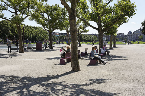
 Max Euweplein, Amsterdam ©2011 J.Crawford The History of Planning in Vancouver and HamiltonNicholas Kevlahan is described as a "passionate amateur urbanist and a fan of good design." Having lived in both Vancouver, British Columbia, and Hamilton, Ontario, he recently published an analysis of the fates of these two once-comparable cities over the past four decades. He found some important differences in the choices the two cities made and the long-term effects.He begins: "Vancouver and Hamilton were remarkably similar cities 40 years ago, but deliberate choices have put these two cities on diverging paths." Today Vancouver is a world-class city and Hamilton is a minor city most people have never heard of. What happened? Some of it, of course, is geography. Vancouver is an excellent port with access to the rapidly-expanding Pacific Rim economies. Hamilton is overshadowed by nearby Toronto. The Toronto Star recently said of Hamilton: This is a city that has made every mistake in the book, and has the scars to prove it. Few urban centres have managed to inflict as much damage on themselves as has Hamilton. After eviscerating its core in the 1960s and '70s, it seems to have run out of any clear sense of where it was headed and why.The two cities are remarkably similar in population, being the 8th and 9th largest cities in Canada. Both have well-defined geographic constraints, and both are part of much larger conurbations. Both have so-so weather, although Hamilton is colder in winter and hot in summer. Now for some important difference. While Vancouver is almost entirely urban, only 20% of Hamilton is urban. Vancouver is the center of a region, while Hamilton is secondary to Toronto. There are large differences in population density, with Vancouver being nearly twice as dense. Hamilton has the misfortune to be cut nearly in half by a steep escarpment that has very few street crossings. Vancouver is on a peninsula surrounded mostly by water. Both cities had only one direction open to sprawl development: to the south in Hamilton, and to the east along the Fraser Valley in Vancouver. Both provincial governments attempted to limit sprawl by defining a greenbelt. However, the Vancouver greenbelt was established in 1974-1976, but the Hamilton greenbelt was only established in 2006. Hamilton's economy was historically based on heavy manufacturing, which has largely disappeared over the past three decades. This has posed an enduring problem for the city's finances. This is often cited as a cause of the city's decline. However, Vancouver has essentially no manufacturing. Vancouver was economically depressed from the 1930s until the late 1960s. Vancouver has relatively low property taxes and is now economically successful. Cities do not need manufacturing or financial centers to thrive, but they do need to be attractive places to live and work. Vancouver focused on livability and getting the most out of its infrastructure investment. By 1970 both cities had ripped out their streetcar lines and made streets one-way to improve traffic flow. Transportation planning focused on private cars. Both cities had also begun densification by demolishing many blocks of large houses near the downtown core, to be replaced by denser construction. However, in the early 1970s Vancouver made a fundamental choice that determined its future. After a huge fight, Vancouver rejected a freeway system in the downtown core. It is now the only North American city without a freeway. A strong tradition of citizen engagement is perhaps the most important legacy of the freeway protests. Hamilton instead built freeways and severed its waterfront from the city. The city briefly considered a plan to reestablish its tram network but abandoned the idea. The city Council has a long tradition of ignoring consultants, planners, and the citizens at large. While Hamilton has recently put pedestrians at the top of the transportation hierarchy (which had been the case in Vancouver for 15 years), there is as yet no sign that city departments will be reorganized in ways that actually reflect this decision. Policies have not been changed in ways that would reflect pedestrian priority. In Vancouver, after the downtown freeway was rejected, city authorities accepted that the standard auto-centric North American development model was off the table. A different approach would be required. Vancouver developed a unique urban planning system, now know as the "Vancouver model," which has produced today's livable city. There would be no additional room for single-occupancy vehicles: no more roads, no road-widening. Resources were increasingly devoted to priorities that put pedestrian first, then cyclists, transit users, and finally car drivers. Vancouver decided what sort of city it wanted to be and has stuck to this vision for forty years. During this period both left- and right-wing councils were in power, and the city cycled through and economic booms and busts. The planning department is largely independent of Council influence, and Vancouver has had more than thirty years of consistent, effective urban planning. In Hamilton, the progressive ideas of the planning department are often ignored or opposed by council. The traffic department still has effective veto power. Even small decisions remain contentious, and projects are delayed for years. What are the elements of the Vancouver model?
Hamilton, by contrast, remains largely subject to the whims of developers. The city seems to feel that it must accept whatever is proposed. Vancouver has more money to spend because the higher density leads to reduced per-capita infrastructure costs. Hamilton continues low-density, greenfield sprawl, which costs the city more than it can afford. Vancouver's property taxes are much lower than Hamilton's. Density does require good rapid transit, a high-quality pedestrian experience, and mixed-use zoning, all characteristic of today's Vancouver.
"A Distant Mirror: 40 Years of Urbanism in Vancouver" |
Video of the Quarter
|
Eindhoven, the Netherlands 5:20 |
Feature ArticlePortland's Portal of OpportunityBy Fanis GrammenosFirst read "Beloved and Abandoned: A Platting Named Portland" in the previous issue. In that article, Fanis Grammenos challenged planners' assumptions about the superiority of the rigid street grid, exemplified by Portland, Oregon. In this follow-up, Grammenos praises a neighborhood of Portland that took a different approach altogether to the organization of streets. In an earlier article about the Portland grid, I identified a number of its shortcomings and speculated that they may be the reason it has not been replicated; no other discernible obstacles would seem to block the way and praise of it has been plentiful. In the meantime, research and events recast the Portland grid as a potential ground for a pioneering transformation. Such a remoulding can sharpen Portland's already strong profile as a center of urbanism that transcends mere historicism and becomes fully contemporary. Research and EventsThe earlier article noted that Portland's praised intersection (140 per km2) and street density comes at a heavy cost. It means reduced developable land, higher infrastructure cost, higher lifecycle costs, reduced traffic flow and safety, reduced rainwater permeability and fewer opportunities for public open space.
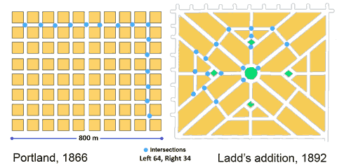 Figure 1. The Portland Grid and Ladd's Addition layouts - same scale While the article recognized the grid's high legibility and walkability, it pointed out that these valued characteristics were, evidently, insufficient to create a following. There has been no copy of it in North America or elsewhere since 1866. We observed that even in Portland itself, and shortly after its platting, deviations from its stereotypical grid started to emerge, an example of which is Ladd's Addition (1891). It turns out this Addition was an extraordinary and remarkable deviation. By coincidence, as our critique surfaced, the American Planning Association (APA) named Ladd's Addition "a great neighborhood" under their ongoing program that recognizes planning achievements. Then new research appeared on "Emergent Neighborhoods" (EN) by four well-known urbanists that revealed the 400-m rule and the importance of "sanctuaries". Ladd's neighborhood, it would seem, is a living demonstration of these two concepts. The "great neighborhood" designation and the new research findings spurred a revisit of the Portland grid with a focus on a potential transformation that would amend its weaknesses and in the process of doing so offer a template for other existing cities that are laid out in uniform, undifferentiated grids. This re-think also responds, belatedly, to a challenging comment: "....Rather than this grab-bag of criticisms, it would be more useful to develop a consistent positive alternative to the Portland grid". The Ushers of OpportunityThe APA follows a rigorous selection process and uses a clear set of criteria for awarding a neighborhood the status of "great". In the case of Ladd's Neighborhood the rationale presented for awarding the title was as follows:
The hierarchy of streets in an era of horse, cart and coach would seem hardly necessary as neither the traffic volume nor its speed would be sufficient to justify it; they bear no comparison with contemporary numbers that are at least an order of magnitude higher. Moreover, this was a subdivision carved out of farmland and Douglas fir forest across the river away from the city. It was intended as an exclusive residential enclave for wealthy Portlanders who sought a quiet place in the "country" (1891). Whatever the original motivation, the hierarchy of streets serves the neighborhood well 100 years hence; yet, evidently, not well enough. Even though the disruption of the surrounding grid inevitably prevents direct flow of through traffic (another APA point of recognition), it did not do it adequately until after residents and the City introduced additional exclusion and diversion measures to achieve a dramatic, and welcome, reduction from 6,000 Average Daily Trips (ADT) to 1500 ADT. By virtue of the disruption of the grid, the boundaries of this neighborhood confront the driver boldly. Most of the surrounding streets terminate at these boundaries signalling an enclave, a "sanctuary" that one has to circumvent. Navigating through its four quadrants can be confusing to a visitor since the plan defies the familiar orthogonal geometry, even though all its streets are rectilinear and none a dead-end. Having a strong sense of community identity and an appreciation of its valued attributes, residents fought and achieved a down-zoning of its future density. Though by no means urban at 7 dwelling units per acre (18 per ha), it seems to produce a satisfying milieu. The residents have embraced the result and the APA lauds their strong attachment. Emergent Neighborhood ResearchCharacterizing the boundary thoroughfares and quiet enclaves as "natural", new research on Emergent Neighborhoods (EN) presents the case of the 400m spacing rule and the "sanctuary" as organizing principles of existing city districts. Both principles can be seen in Ladds addition. It is about 800 m long by 600 m wide and bisected in both directions at half points with straight through streets, with an interrupting large, landscaped roundabout. Thus four neighborhoods, quadrants, or "sanctuaries" are created.The 400m rule reflects the finding that communities tend to include significant thoroughfares that are endowed with services at about 400 m intervals. The areas enclosed by them are primarily residential and their street pattern discourages non-residents from going through the loosely defined enclave. The authors argue that if such a pattern of self-organization can be observed almost universally, it might be a useful blueprint for planners to follow in layouts for new districts. Were planners to do so, they would be simply applying an "organic" formula that has been tested by time and proven to work. From the perspective of this EN research, the uniform Portland grid is uncharacteristic (one might say unnatural) and unable to follow the 400 m rule or to form sanctuaries. Its unnaturalness may be unsurprising when one considers that it was a speculators and land surveyors preferred method of layout: simple, repetitive, fast and less prone to boundary disputes. Contrary to the examples, cited in the EN research, that emerged organically, the grid was a "rational", imposed solution. Biophilia and PatternsRecent research has established that humans take pleasure in being in nature and that natural setting and living things can have a therapeutic influence on people. This affinity and relationship is thought to be based on mans common chain of evolution with all living things. Critics see some urban conditions as the cause of what is termed "nature deficit". An extension of this connection with nature is the proposition that human artefacts, including cities, often exhibit the geometry of living organisms. In that geometry, the parts do not make a whole, it is the whole that shapes the parts in constant co-evolution.The Elements of TransformationTo these germane ideas, 400m rule, sanctuaries, departure from the grid, biophilia and the whole-part relationship one must add three others by C. Alexander, whom the EN research authors revere as a mentor. Alexander argued that roads within a neighborhood should be discontinuous to induce the sanctuary atmosphere and to that end he proposed patterns that relate to vehicular and pedestrian movement: Pattern 49 (Looped Streets), Pattern 51 (Green Streets) and Pattern 52 (Paths and Cars).
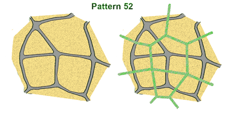 Figure 2 (after Alexander): Paths and Cars #52 : left, roads only, right, with overlaid paths The latter pattern states that the recommended way to lay out pedestrian paths is to have them run independently and perpendicular to roads, wherever possible (Figure 2). A Portal of OpportunityThe APA rationale combined with the Emergent Neighborhood research findings and Alexanders patterns generate a set of guidelines that lay the foundation for Portland's portal of opportunity:
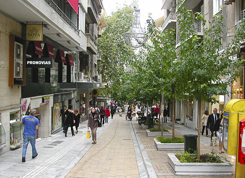 Figure 3. Kolonaki Street, Athens, similar to one of Pearl District's Green Streets. In the Pearl district a number of streets have been closed to traffic to great advantage and delight. Similar closures have occurred elsewhere sporadically in Portland. More extensive closures have occurred in the central areas of small and large European cities such as Strasbourg, Montpellier, Munich, Athens and others. Many of these reclaimed streets are predominantly residential with an occasional mixed use on the ground floor. In addition to full closures, there have been partial and controlled, managed closures. (See Figure 6 from Paris.) Using the full panoply of these ideas and practical measures, Portland is uniquely positioned to transform its residential districts into multiple, virtual Ladd's Additions while leaving the entire infrastructure and real estate intact. These new districts would represent an evolution of its grid, an adaptation to the contemporary means of transport and to the environmental imperatives of less driving, more walking and greater water retention on site: From a uni-modal grid, dominated by motorized mobility to a multi-modal grid where natural mobility reclaims its share of the neighborhood network.
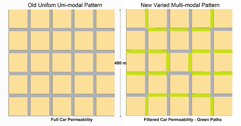 Figure 4: Transcending the Portland grid: Left, the uni-modal grid and Right, transformed into a multi-modal, fused grid. Figure 4 shows one of many possible end-states of transformation. In this version:
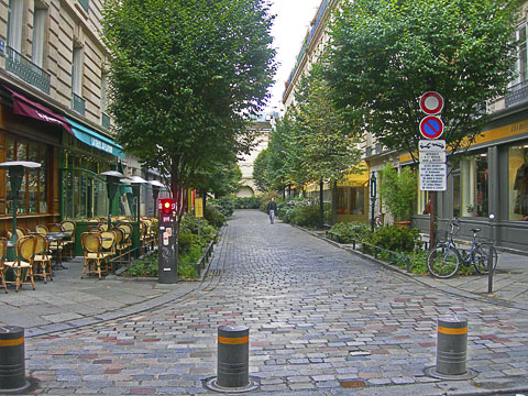 Figure 5. Controlled access with retractable bollards a management approach to transforming streets (note the discontinuous sidewalk on the left). This example simply sets out a logical sequence of displacing asphalt with landscaping in a way that streets and paths are direct and interconnected. One sanctuary at a time, large residential districts can become the newest Ladd's Additions of Portland. Inevitably, the question of traffic surfaces. The Ladd's district traffic calming initiative provides the answer. However, in this case, the new plan has unparalleled inherent flexibility, unlike its inspirational model. Should additional streets be needed to accommodate growth and traffic flow, at some future date, returning carefully selected streets, according to need, to their original asphalt state would encounter few difficulties. The City has unfettered jurisdictional power over streets, a public domain, to implement any desired transformations deemed to be in the public good. Such initiative would not be exceptional. Several European cities have dealt with large downtown areas that had complex, labyrinthine networks and significant built infrastructure of historic value. (see Bremen, Germany, for example) They all accommodated traffic and services through careful planning and management.
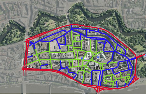 Figure 6. The old city centre of Bremen, Germany uses a blended network of car (blue) and pedestrian streets (green) to transform the area into a pedestrian haven. (Google Earth images) This transformation might also serve for another form of evolution. If later in the century some of the transformed neighborhoods become subject to strong intensification pressure, the green streets can be built above and become "stoas" full-fledged passages through the building (following the street's ROW alignment) that perform all the functions of a street except car movement. Interestingly, these will materialize yet another of Alexanders patterns Building Thoroughfare (#101). Not only would these new type of connectors add variety (and protection) in the built environment; they would also earn real estate income for the city. Symbolically, these will be the portals to future urban landscapes.
 Figure 7. A "stoa": A through-the-building arcade that connects two parallel streets. In summary, according to credible research and arithmetic these measures will:
Originally published at Planetizine. Thanks to them and the author for allowing this reprint.
Presentation materials (please cite Fanis Grammenos as the source) Fanis Grammenos is a principal of Urban Pattern Associates and was a Senior Researcher at Canada Mortgage and Housing Corporation for over 20 years. He focused on housing affordability, building adaptability, municipal regulations, sustainable development and, recently, on street network patterns. Prior to that he was a housing developer. He holds a degree in Architecture from the U of Waterloo.
 Max Euweplein, Amsterdam ©2011 J.Crawford Hot New Links |
|
The links below will open in a new browser window:
"Making Freeways Obsolete" in the New Colonist. Describes an ambitious but feasible plan for new infrastructure in Los Angeles that would reduce the impact of port facilities, improve efficiency, add high-grade public transport, and provide ideal locations for carfree districts. "Universal Principles for Creating a Sustainable City." Lessons to be learned from post-war Freiburg, Germany. "Should We Launch an All-Out Assault on Car Culture?" How the Right is setting up the straw man of a "war on cars" that doesn't exist. "rethink / relandscape / rehabilitate" from RehabRd. Proposes major changes to Oxford Street, London, and Bygdøy Allé, Oslo. Shows how graphics can be used to sell pedestrianization.
 Max Euweplein, Amsterdam ©2011 J.Crawford About Carfree TimesNext IssueThe next issue of Carfree Times is scheduled for November/December 2011.
Subscribe to Carfree TimesCarfree Times is published quarterly at Carfree.com. To receive e-mail notices of new issues, please visit the subscription page or send e-mail with the word "Subscribe" in the subject line. We do not share our mailing list.Write for Carfree TimesInterested in writing for Carfree Times? We welcome articles on a wide variety of subjects and offer an opportunity to publish letters to the editor and guest editorials. Drop us an e-mail.
|
| Editor | J.H. Crawford |
| Send e-mail | |
| URL | http://www.carfree.com/
|
Back to Carfree.com
Carfree Times Home
Back to Carfree Times Issue 62
Forward to Carfree Times Issue 64
E-mail
carfree.com
Illustrations copyright ©2011 J.Crawford
Text, except for guest articles, placed in the public domain